GIS Mapping Services
Accurate mapping solutions to support smart planning and sustainable development
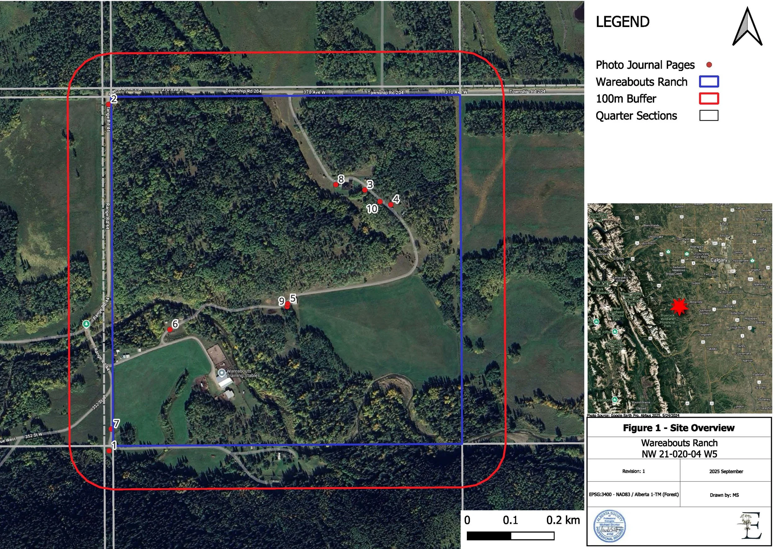
Understanding a project's environmental constraints begins with accurate data. At Ethos Enviro, we use advanced GIS (Geographic Information Systems) mapping tools to collect, analyze, and present spatial information in a way that’s practical and easy to use. From identifying sensitive habitats and rare plant populations to mapping terrain and site features, our services provide a detailed biophysical render of your project area. With this insight, you can plan ahead and reduce costly surprises during development.

Advanced GIS and Spatial Analysis Services
We provide spatial analysis services that uncover patterns, trends, and relationships within your project area. From land use mapping to environmental GIS assessments, our specialists deliver the insights you need to make informed decisions.
As trusted GIS consultants in Canada, we support industries navigating complex environmental regulations and sustainability requirements. Whether it’s identifying the most suitable land for development, managing sensitive habitats, or optimizing resource use, our GIS expertise ensures proper planning and reduced project risks.
Types of GIS Mapping Services
-

Spatial Data Analysis
We collect biophysical data (soil depts, nest locations, wetland boundaries) This helps clients identify risks, optimize land use, protect natural features, and ensure compliance with regulatory requirements.
-

Rare Plant and Habitat Surveys
GIS mapping supports ecological surveys by pinpointing rare plant populations and sensitive habitats. This ensures that developments minimize environmental impacts while meeting conservation standards.
-

Environmental Impact Mapping
Our team uses GIS to visualize and assess potential environmental impacts of proposed projects. These maps provide regulators and stakeholders with a clear picture of how land use decisions affect ecosystems.
-

Hydrological and Watershed Mapping
This service maps water flow, drainage patterns, and watershed boundaries. It is widely used in flood risk assessments, stormwater planning, and wetland management.
-

Soil and Land Capability Mapping
This mapping identifies soil types and evaluates land capability. It helps determine suitability for agriculture, forestry, reclamation, and land planning.
-
Data Collection & Integration
We combine field-collected data with existing spatial datasets to create accurate, real-time maps. This integration provides a reliable foundation for planning, permitting, and long-term environmental monitoring.

Who We Work With
Our GIS services support a range of clients and projects, including:
Environmental Management
Oil & Gas
Mining & Resource Extraction
Forestry
Utilities & Infrastructure
Transportation & Logistics
Agriculture
Water Resource Management
Wildlife & Habitat Conservation
Emergency Response & Disaster Management
We tailor every project to match your site conditions, timeline, and environmental goals.
FAQs About GIS Mapping Services
-
GIS (Global Information Systems) is a technology that collects, analyzes, and visualizes spatial data. It allows users to see geographic patterns, relationships, and trends that help developers make better decisions.
-
GIS mapping is widely used by environmental consultants, government agencies, agricultural planners, engineers, utility companies, and natural resource managers to plan, monitor, and manage land and resources.
-
GIS provides accurate, data-driven insights for land use, environmental compliance, water management, and resource planning. It helps reduce risks and ensure projects align with regulations and sustainability goals.
-
GIS can be used for vegetation and habitat mapping, hydrological mapping, soil capability mapping, infrastructure mapping, and wildlife corridor analysis, amongst other things. Each use case can support specific environmental and development needs.
-
Yes. GIS mapping is a core tool in environmental assessments, helping to identify sensitive habitats, evaluate land impacts, and plan restoration or mitigation strategies.
-
No. GIS mapping is equally valuable for small-scale land assessments, property development, and site-specific environmental planning. It scales according to the project’s complexity.
Contact Us
Interested in working together? Fill out some info and we will be in touch shortly.
